


-Baldur’s-Gate-3-The-Final-Patch---An-Animated-Short-00-03-43.png?width=1920&height=1920&fit=bounds&quality=70&format=jpg&auto=webp#)


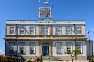
Geographical Institute of the University of Porto in Vila Nova de Gaia, Portugal
A top a hill across from Porto's old town, an unassuming white and gray building was once an epicenter of Cold War conflict. The original structure was built in 1833 to serve as a weather observation station assisting merchants bringing their cargo to port. In 1911, the building was handed over to the College of Sciences at Porto University, who still owns it today. Otherwise an unassuming building, in the 1960s, the site became a place of intrigue for something built under its foundation. With the rise of the Cold War, the United States took an interest in underground nuclear testing. Between the 1950s and 1990s, a network of 120 seismographs were established around the globe as part of the United State's World-Wide Standard Seismographic Network. Seismographs can be used to record seismic waves or vibrations in the ground, helping to predict events like earthquakes, but in this case, the U.S. was more interested in monitoring underground nuclear tests carried out by the Soviet Union. As a part of the project, in 1963, the Geographical Institute of the University of Porto received its own bunker and subterranean seismograph for "scientific research," making Porto a place of significance in the Cold War conflict. Today, the seismic station is still in operation, but is now focused on detecting natural seismic activity and gathering information for research in the geophysical sciences. The buildings hill top location also makes it possible to see all six bridges that connect Gaia to Porto, from Arrábida to Freixo.

A top a hill across from Porto's old town, an unassuming white and gray building was once an epicenter of Cold War conflict.
The original structure was built in 1833 to serve as a weather observation station assisting merchants bringing their cargo to port. In 1911, the building was handed over to the College of Sciences at Porto University, who still owns it today. Otherwise an unassuming building, in the 1960s, the site became a place of intrigue for something built under its foundation.
With the rise of the Cold War, the United States took an interest in underground nuclear testing. Between the 1950s and 1990s, a network of 120 seismographs were established around the globe as part of the United State's World-Wide Standard Seismographic Network. Seismographs can be used to record seismic waves or vibrations in the ground, helping to predict events like earthquakes, but in this case, the U.S. was more interested in monitoring underground nuclear tests carried out by the Soviet Union.
As a part of the project, in 1963, the Geographical Institute of the University of Porto received its own bunker and subterranean seismograph for "scientific research," making Porto a place of significance in the Cold War conflict.
Today, the seismic station is still in operation, but is now focused on detecting natural seismic activity and gathering information for research in the geophysical sciences. The buildings hill top location also makes it possible to see all six bridges that connect Gaia to Porto, from Arrábida to Freixo.