


Lake San Cristobal in Hinsdale County, Colorado
About 800 years ago, a large section of Mesa Seco on the edge of the Lake City caldera broke off and moved down the steep slopes of the mesa. Rather than a large slide of rock, which would be common in the steep Colorado Rockies, the material flowed down the hill, almost like a river. This river of rock, mud, and gravel was called the Slumgullion Mass Flow. It flowed about four miles into the Lake Fork of the Gunnison River over the next 100 years or so. Called the active foot, the slide moved down the river valley as well as upstream. The debris filled a narrow gorge and dammed the existing river. Water backed up into the alpine valley above the gorge to a depth of 89 feet, 2 miles long, and 0.5 miles wide. Lakes created by landslides are not uncommon. However, water usually overflows the dam and causes the dam to be eroded within months or years. The size of the Slumgullion Mass Flow and the nature of the gorge cut by the Gunnison River resulted in a stable earth fill dam that has lasted 700 years. The material that makes up the Slumgullion Mass Flow contributes to the stability of the dam. The material is highly pulverized and contains a large percentage of clay. The resultant dam is relatively water-tight without much leakage. The volcanic rock that underlies the river in the area is also very erosion resistant. These factors result in a stable dam. Concerns about the state of the lake and the known nature of landslide lakes have prompted several studies of the outlet. Attempts have been made to stabilize the earthen dam that have been deemed unnecessary and have degraded faster than the natural material. Currently, a small head wall has been built across the outlet and the flow of water is controlled by the placement of boulders to control the height of the lake. The lake is gradually being filled by debris washed in by the Lake Fork of the Gunnison and Slumgullion Creek. Current estimates are that the lake will fill with sediment in about 2500 years.

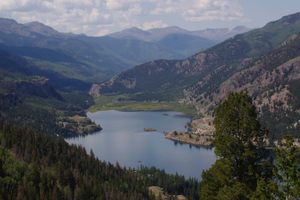
About 800 years ago, a large section of Mesa Seco on the edge of the Lake City caldera broke off and moved down the steep slopes of the mesa. Rather than a large slide of rock, which would be common in the steep Colorado Rockies, the material flowed down the hill, almost like a river.
This river of rock, mud, and gravel was called the Slumgullion Mass Flow. It flowed about four miles into the Lake Fork of the Gunnison River over the next 100 years or so. Called the active foot, the slide moved down the river valley as well as upstream. The debris filled a narrow gorge and dammed the existing river. Water backed up into the alpine valley above the gorge to a depth of 89 feet, 2 miles long, and 0.5 miles wide.
Lakes created by landslides are not uncommon. However, water usually overflows the dam and causes the dam to be eroded within months or years. The size of the Slumgullion Mass Flow and the nature of the gorge cut by the Gunnison River resulted in a stable earth fill dam that has lasted 700 years.
The material that makes up the Slumgullion Mass Flow contributes to the stability of the dam. The material is highly pulverized and contains a large percentage of clay. The resultant dam is relatively water-tight without much leakage. The volcanic rock that underlies the river in the area is also very erosion resistant. These factors result in a stable dam.
Concerns about the state of the lake and the known nature of landslide lakes have prompted several studies of the outlet. Attempts have been made to stabilize the earthen dam that have been deemed unnecessary and have degraded faster than the natural material. Currently, a small head wall has been built across the outlet and the flow of water is controlled by the placement of boulders to control the height of the lake.
The lake is gradually being filled by debris washed in by the Lake Fork of the Gunnison and Slumgullion Creek. Current estimates are that the lake will fill with sediment in about 2500 years.