


-Baldur’s-Gate-3-The-Final-Patch---An-Animated-Short-00-03-43.png?width=1920&height=1920&fit=bounds&quality=70&format=jpg&auto=webp#)


Plan the ultimate road trip between three iconic California national parks
Yosemite, Sequoia and Kings Canyon National Parks have some of California's most majestic landsapes. Here's what to do at each stop.

Glacier-carved valleys resting below dramatic peaks make Yosemite National Park an all-ages playground. Witness earth-shaking waterfalls, clamber up granite domes and camp out by high-country meadows where wildflowers bloom in summer. Home to the USA’s deepest canyon and the biggest tree on the planet, Sequoia and Kings Canyon National Parks justify detouring further south into the Sierra Nevada, which conservationist John Muir called “The Range of Light.”
This road trip between all three parks spotlights some of California’s most majestic landscapes, showing you what to do at each stop and how to get to the next one. Due to National Park Service staffing cuts this year, travelers can expect longer wait times, fewer services and the potential closures of certain areas. Stay prepared with this guide.
Duration: 5-7 days
Distance: 450 miles (725km)
Best time to go: April and May for waterfalls; June to September for full access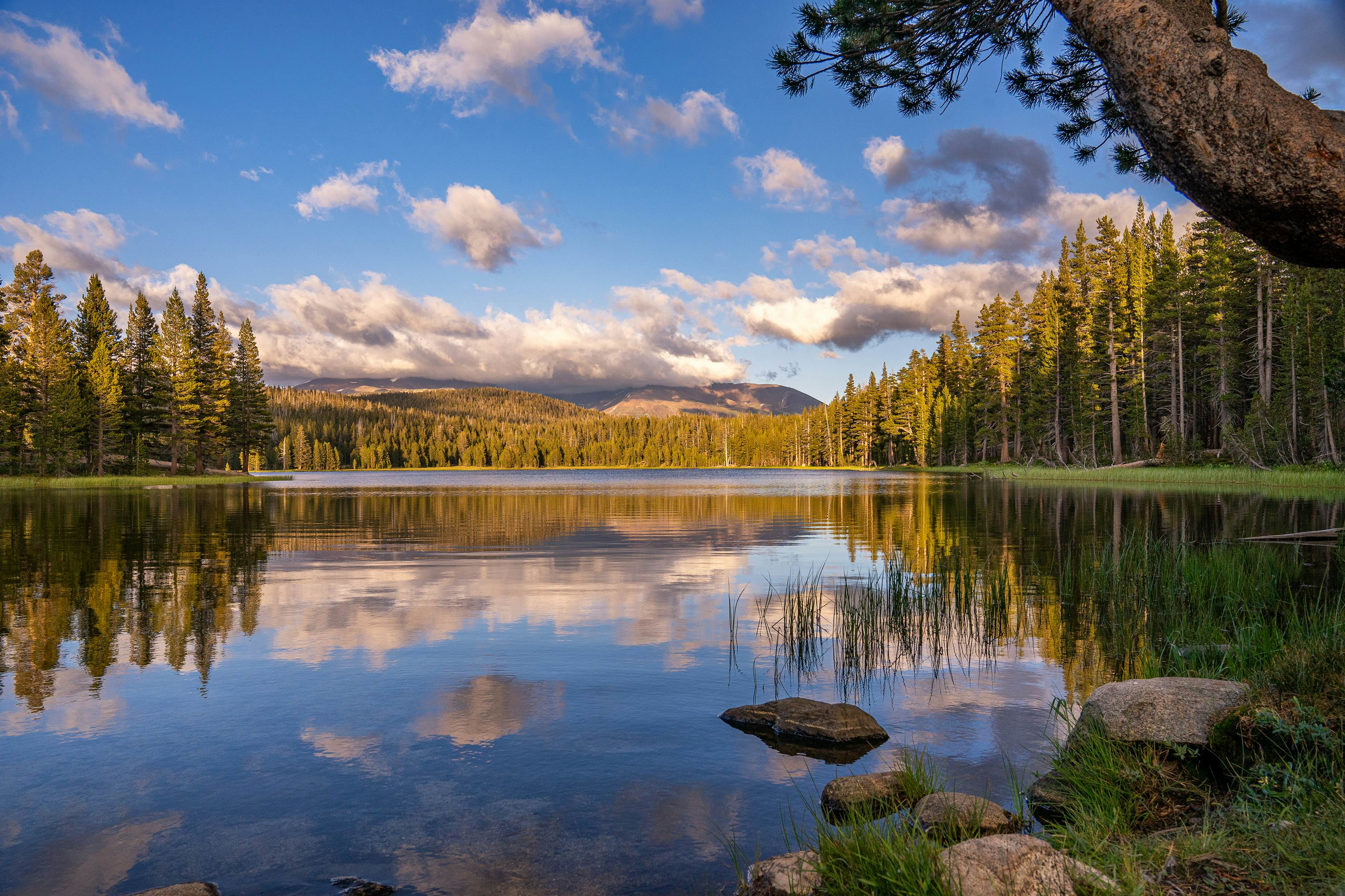
Start: Tuolumne Meadows
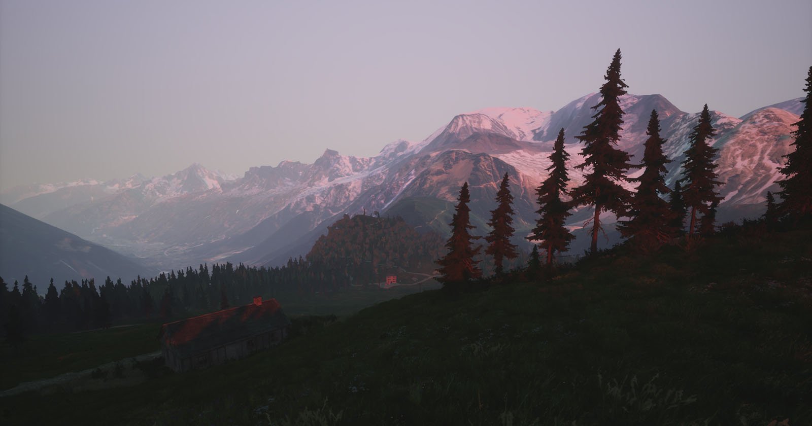
Tuolumne Meadows makes for an impressive introduction to the Yosemite area. These are the Sierra Nevada’s largest subalpine meadows, with fields of wildflowers, bubbling streams, ragged granite peaks and cooler temperatures at an elevation of 8600ft. Hikers can find a paradise of trails to tackle, or unpack a picnic basket by the stream-fed meadows. Tioga Rd, the 19th-century wagon road and Native American trading route that crosses the Sierra, usually reopens in May or June and remains passable until October or November. Nine miles west of the meadows, a sandy half-moon beach wraps around Tenaya Lake, tempting you to brave some of the park’s coldest swimming. Sunbathers lie upon rocks that rim the lake’s northern shore. A few minutes further west, stop at Olmsted Point. Overlooking a lunar-type landscape of glaciated granite, you can gaze deeply down Tenaya Canyon to Half Dome’s backside.
Stay: Pitch a tent at Tuolumne Meadows Campground, with sweeping views at 8600ft of the Sierra Nevada and Yosemite’s famous domes. Another great option is Sunrise High Sierra Camp, accessible from Lake Tenaya or Tuolumne Meadows via the John Muir Trail. It has nine cabins and offers day hikes to Cathedral Peak, Clouds Rest and Half Dome.
The drive: From Tuolumne Meadows, it’s 50 miles to Yosemite Valley following Tioga Rd (Hwy 120), turning south onto Big Oak Flat Rd and then east onto El Portal Rd. There’s one must-do stop before entering the valley proper, Tunnel View, so follow Wawona Rd west for a few miles where it forks with Southside Dr. You’ll know you’ve arrived when you see all the other parked cars.
Stop 1: Tunnel View
For your first spectacular look into Yosemite Valley, pull over at Tunnel View, a vista that has inspired painters, poets, naturalists and adventurers for centuries. On the right, Bridalveil Fall swells with snowmelt in late spring, but by late summer, it’s a mere whisper, often lifted and blown aloft by the wind. Spread below you are the pine forests and meadows of the valley floor, with the sheer face of El Capitan rising on the left and, in the distance straight ahead, iconic granite Half Dome.
The drive: Merge carefully back onto eastbound Wawona Rd, which continues downhill into Yosemite Valley, full of confusingly intersecting one-way roads. Drive east along the Merced River on Southside Dr past the Bridalveil Fall turnoff. Almost 6 miles from Tunnel View, turn left and drive across Sentinel Bridge to Yosemite Village’s day-use parking lots. Ride free shuttle buses that circle the valley.
Stop 2: Yosemite Valley
From the bottom looking up, this valley cut by the meandering Merced River is song-inspiring, and not just for birds: It has rippling meadow grasses; tall pines; cool, impassive pools reflecting granite monoliths; and cascading, glacier-cold white-water ribbons. At busy Yosemite Village, start inside the Yosemite Valley Visitor Center, with its thought-provoking history and nature displays and free Spirit of Yosemite film screenings. At the nearby Yosemite Museum, Western landscape paintings are hung beside Native American baskets and beaded clothing.
The valley’s famous waterfalls are thunderous cataracts in May but mere trickles by late July. Triple-tiered Yosemite Falls is North America’s tallest, while Bridalveil Fall is hardly less impressive. A strenuous, often slippery staircase beside Vernal Falls leads you, gasping, right to the top edge of the waterfall, where rainbows pop in clouds of mist. Keep hiking up the same Mist Trail to the top of Nevada Falls for a heady 5.5-mile round-trip trek. In midsummer, you can rent a raft at Curry Village and float down the Merced River. The serene stretch between Stoneman Bridge and Sentinel Beach is gentle enough for kids.
Stay: Go all out at the historic Ahwahnee Hotel, or spend the night closer to nature in a tent cabin at Curry Village.
The drive: Use Northside Dr to loop around and join Wawona Rd again. Follow Wawona Rd/Hwy 41 up out of the valley. After 9 miles, turn left onto Glacier Point Rd at the Chinquapin intersection, driving 15 more miles to Glacier Point.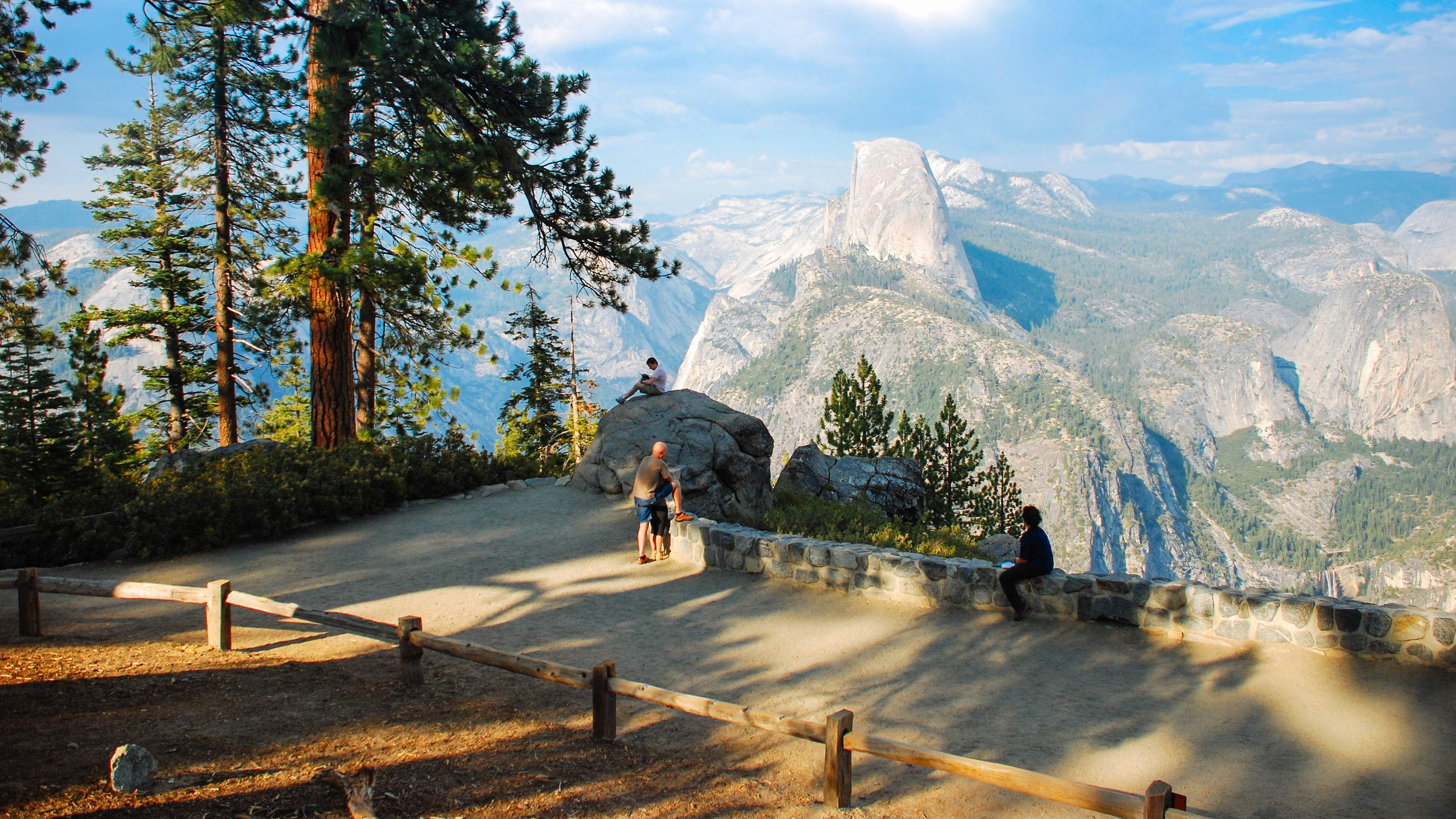
Stop 3: Glacier Point
In just over an hour, you can zip from Yosemite Valley up to head-spinning Glacier Point. Note that the final 10 miles of Glacier Point Rd are usually closed from November through April or May because of snow. During winter, the road remains open as far as the Badger Pass Ski Area, but snow tires and tire chains may be required. Rising over 3000ft above the valley floor, Glacier Point (7214ft) practically puts you at eye level with Half Dome. Glimpse what John Muir and US President Teddy Roosevelt saw when they camped here in 1903: the waterfall-strewn Yosemite Valley below and the distant peaks ringing Tuolumne Meadows. To get away from the crowds, hike a little way down the Panorama Trail, just south of the crowded main viewpoint. On your way back from Glacier Point, take time out for a 2-mile hike up Sentinel Dome or out to Taft Point for incredible 360-degree valley views.
The drive: Drive back downhill past Badger Pass Ski Area, turning left at the Chinquapin intersection and winding south through thick forest on Wawona Rd/Hwy 41. After almost 13 curvy miles, you’ll reach Wawona, with its lodge, visitor center, general store and gas station, all on your left.
Stop 4: Wawona
At Wawona, a 45-minute drive south of the valley, drop by the Pioneer Yosemite History Center, with its covered bridge, pioneer-era buildings and historic Wells Fargo office. In summer, you can take a short, bumpy stagecoach ride and really feel like you’re living in the past. Peek inside the Wawona Visitor Center at the recreated studio of 19th-century artist Thomas Hill, hung with romantic Sierra Nevada landscape paintings. On summer evenings, imbibe a civilized cocktail in the lobby lounge of the Wawona Hotel, where pianist Tom Bopp often plays tunes from Yosemite’s bygone days.
Stay: The Wawona Hotel is a National Historic Landmark dating from 1879. Its six graceful, whitewashed New England-style buildings are flanked by wide porches, and its 104 rooms – with no phone or TV – have Victorian-style furniture and other period items.
The drive: Follow Wawona Rd/Hwy 41 south for 4.5 miles to the park’s south entrance, where you must leave your car at the new parking lot. A free shuttle will take you to Mariposa Grove.
Stop 5: Mariposa Grove
Wander giddily around the Mariposa Grove, home of the Grizzly Giant and 500 other monumental sequoias that tower above your head. Nature trails wind through this popular grove, and an early morning or evening visit is likely to be most peaceful. Notwithstanding a cruel hack job back in 1895, the walk-through California Tunnel Tree continues to survive, so pose your family in front and snap away. If you’ve got the energy, make a round-trip pilgrimage on foot to the fallen Wawona Tunnel Tree in the upper grove.
The drive: From Yosemite’s south entrance station, it’s a 115-mile, three-hour trip to Kings Canyon National Park. Follow Hwy 41 south 60 miles to Fresno, then slingshot east on Hwy 180 for another 50 miles, climbing out of the Central Valley back into the mountains. Keep left at the Hwy 198 intersection, staying on Hwy 180 toward Grant Grove.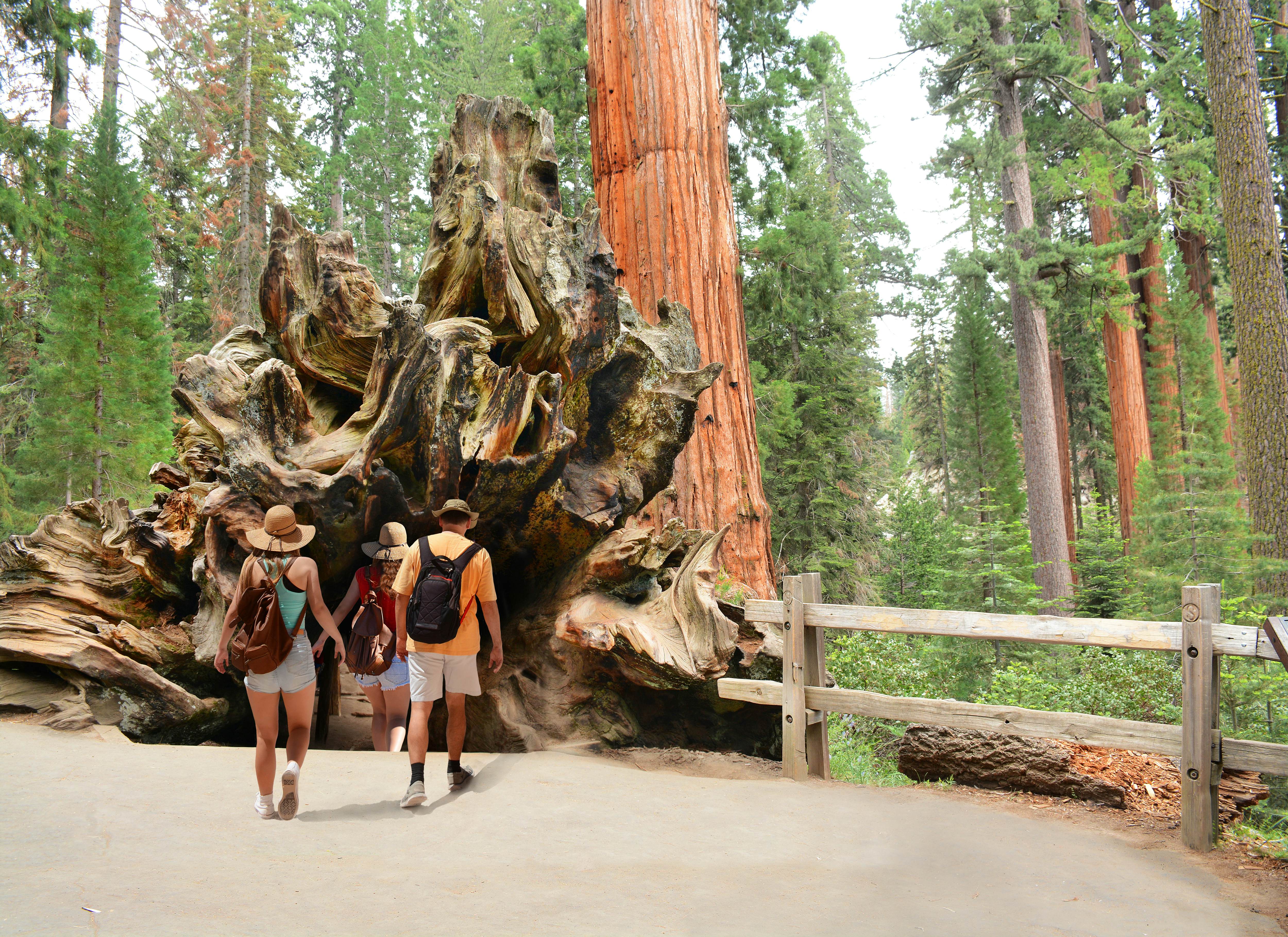
Stop 6: Grant Grove
Driving through Sequoia and Kings Canyon National Parks seems to barely scratch the surface of the twin parks’ beauty. To see real treasures, you’ll need to get out and stretch your legs. North of Big Stump entrance station in Grant Grove Village, turn left and wind downhill to General Grant Grove, where you’ll see some of the park’s landmark giant sequoia trees along a paved path. You can walk right through the Fallen Monarch, a massive, fire-hollowed trunk that’s done duty as a cabin, hotel, saloon and horse stable. For views of Kings Canyon and the peaks of the Great Western Divide, follow a narrow, winding side road (closed in winter; no RVs or trailers) starting behind the John Muir Lodge for over 2 miles up to Panoramic Point.
Stay: Azalea, Sunset and Crystal Springs campsites typically open from late May to early September. For creature comforts and fewer mosquitoes, John Muir Lodge has simple rooms and shared balconies that are ideal for cracking open a beer while watching the forest darken.
The drive: Kings Canyon National Park’s main visitor areas, Grant Grove and Cedar Grove, are linked by the narrow, twisting Kings Canyon Scenic Byway (Hwy 180), which descends into the canyon. Expect spectacular views all along this outstandingly scenic 30-mile drive. Note: Hwy 180 from the Hume Lake turnoff to Cedar Grove is closed during winter (usually mid-November through mid-April).
Stop 7: Cedar Grove
Serpentining past chiseled rock walls laced with waterfalls, Hwy 180 plunges down to the Kings River, where roaring white water ricochets off the granite cliffs of North America’s deepest canyon, technically speaking. Pull over partway down at Junction View overlook for an eyeful, then keep rolling down along the river to Cedar Grove Village. East of the village, Zumwalt Meadow is the place for spotting birds, mule deer and black bears. If the day is hot and your swimming gear is handy, stroll from Road’s End to Muir Rock, a large flat-top river boulder where John Muir once gave outdoor talks that’s now a popular summer swimming hole. Starting from Road’s End, a very popular day hike climbs 4 miles each way to Mist Falls, which thunders in late spring.
Stay: Sheep Creek Campground is a large and shady riverside campsite only a short walk from Cedar Grove Village. If you prefer a bed to a sleeping bag, Cedar Grove Lodge has 21 basic double and queen rooms in a no-frills lodge by the river. The lodge is closed during the winter.
The drive: Backtrack from Road’s End nearly 30 miles up Hwy 180. Turn left onto Hume Lake Rd. Curve around the lake past swimming beaches and campgrounds, turning right onto 10 Mile Rd. At Hwy 198, turn left and follow the Generals Hwy (often closed from January to March) south for about 23 miles to the Wolverton Rd turnoff on your left.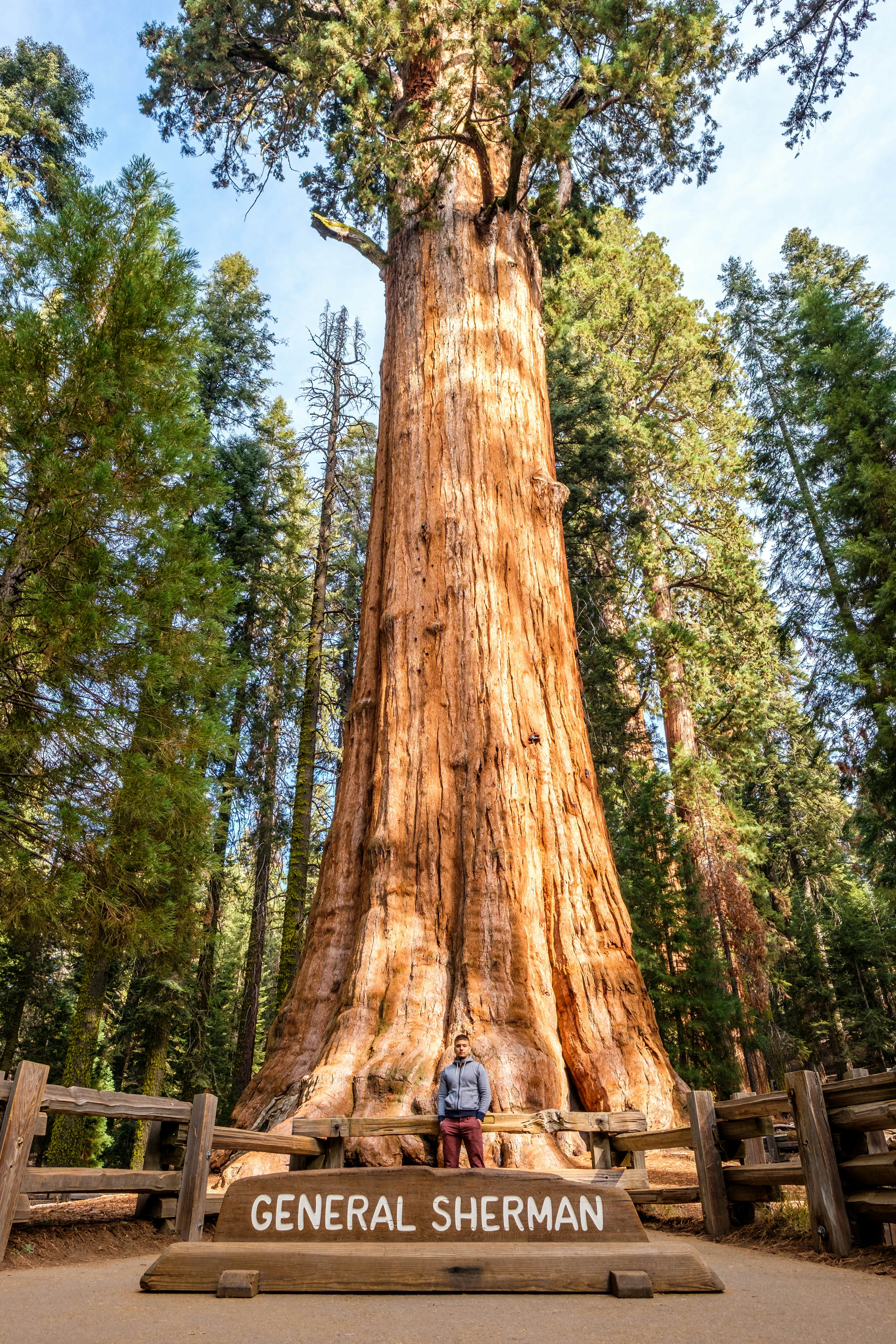
Stop 8: Giant Forest
We dare you to try hugging the trees in Giant Forest, a 3-sq-mile grove protecting the park’s most gargantuan specimens. Park off Wolverton Rd and walk downhill to reach the world’s biggest living tree, the General Sherman Tree, which towers 275ft into the sky. With sore arms and sticky sap fingers, you can lose the crowds on any of many nearby forested trails. The trail network stretches all the way south to Crescent Meadow, a 5-mile one-way ramble. By car, drive 2.5 miles south along the Generals Hwy to get schooled on sequoia ecology and fire cycles at the Giant Forest Museum. Starting outside the museum, Crescent Meadow Rd makes a 6-mile loop into the Giant Forest, passing right through Tunnel Log. For 360-degree views of the Great Western Divide, climb the steep quarter-mile staircase up Moro Rock. Note: Crescent Meadow Rd is closed to traffic by winter snow; during summer, ride the free shuttle buses around the loop road.
The drive: Narrowing, the Generals Hwy drops for more than 15 miles into the Sierra Nevada foothills, passing Amphitheater Point and exiting the park beyond Foothills Visitor Center. Before reaching the town of Three Rivers, turn left on Mineral King Rd, a dizzyingly scenic 25-mile road (partly unpaved, no trailers or RVs allowed and closed in winter) that switchbacks up to Mineral King Valley.
End: Mineral King Valley
Navigating over 700 hairpin turns, it’s a winding 1½-hour drive up to the glacially sculpted Mineral King Valley (7500ft), a 19th-century silver-mining camp and lumber settlement, and later a mountain retreat. Trails into the high country begin at the end of Mineral King Rd, where historic private cabins dot the valley floor, flanked by massive mountains. Your final destination is just over a mile past the ranger station, where the valley unfolds all of its hidden beauty, and hikes to granite peaks and alpine lakes beckon. Note that Mineral King Rd is typically open only from late May through late October. In summer, Mineral King’s marmots like to chew on parked cars, so wrap the undercarriage of your vehicle with a tarp and rope (which can be bought, though not cheaply, at the hardware store in Three Rivers).
Stay: Spend your last night beneath the stars at Cold Springs Campground, a tent-only camping zone with 40 sites tucked away among conifers near the ranger station. Or treat yourself to the luxe cabin life at Silver City Mountain Resort.
This article was adapted from Lonely Planet's Best Road Trips USA.